South America Blog Posts

Week 15 – Down the Bolivian ‘Death road’ and to Caranavi

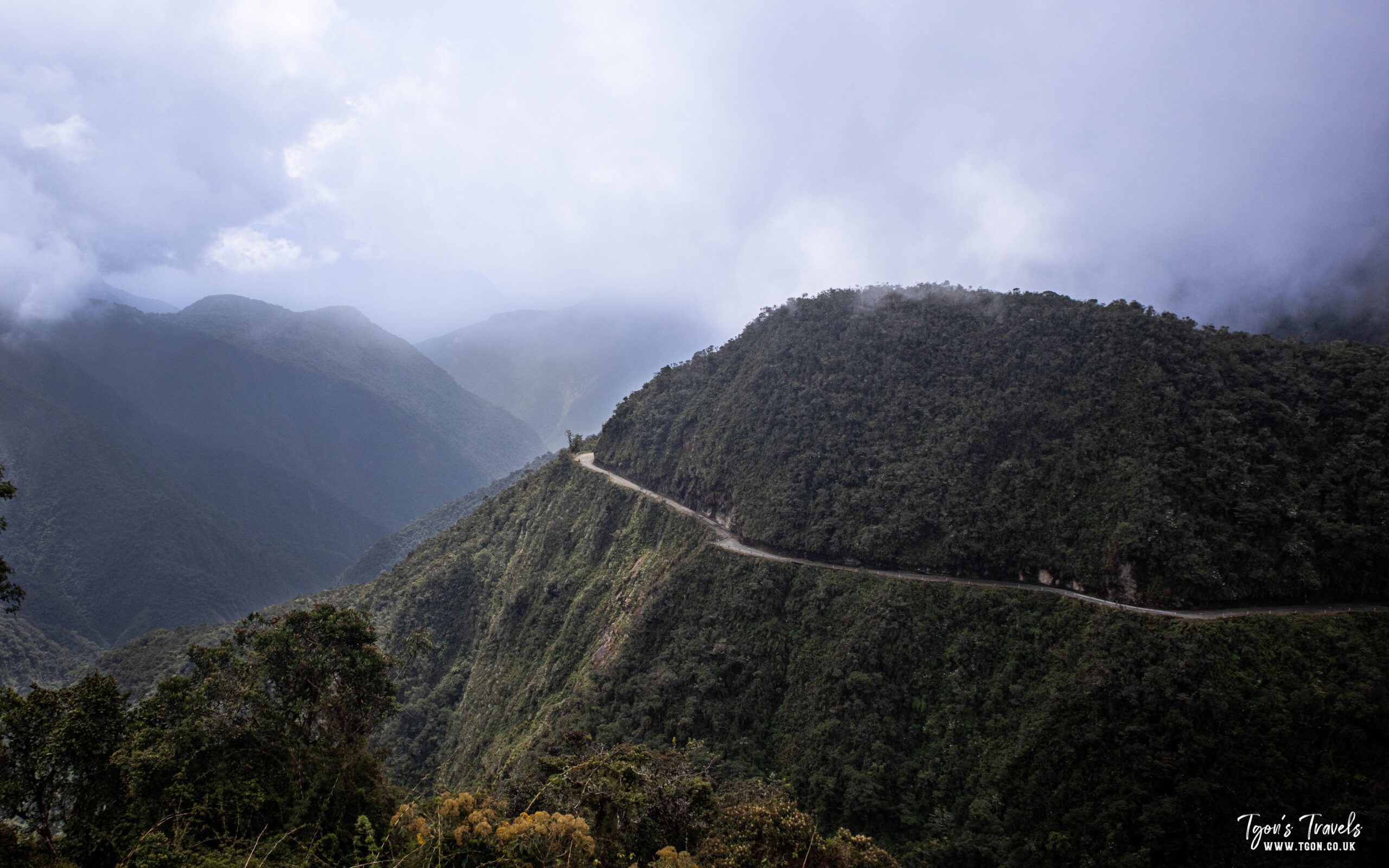
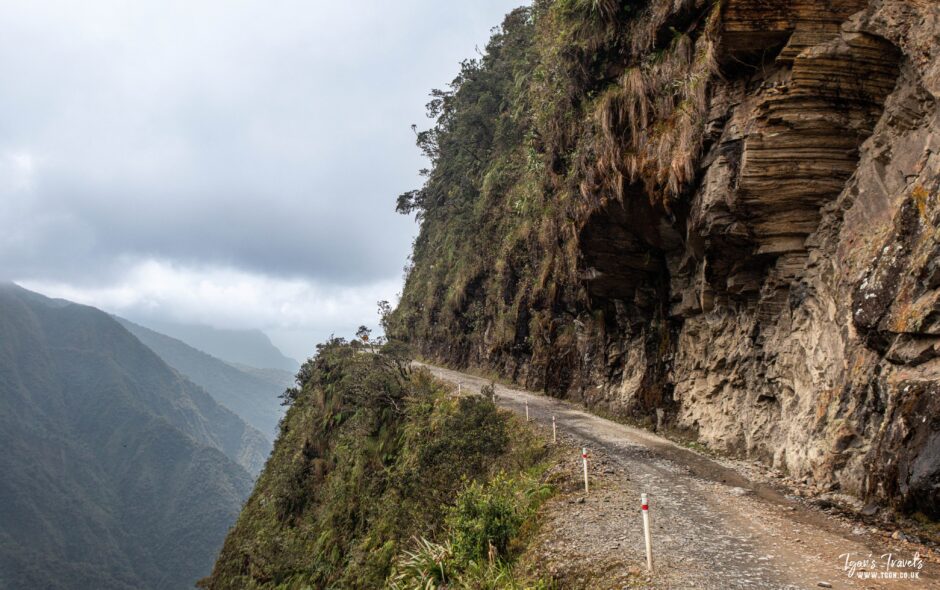
The Bolivian ‘Death Road’ got it’s name from the number of traffic accidents that happened on the road. Most of them occurred when vehicles tried to pass each other on the narrow roads and rolled down the mountain. The road was built to link La Paz with the Amazonian areas of Brazil. It was started using labour from prisoners of war from Paraguay. Because of the number of deaths on the road, the Bolivian government completed a new road in 2006. Since then the road gets very little use, other than tourists on bike tours who are driven there from La Paz, go down the hill then are driven back to La Paz again. So the road is actually very safe, peaceful and beautiful to ride down.

Heading down the ‘Death Road’

I started my week by waking up in the viewpoint at the top of the ‘Death road’. The view was amazing, especially as I hadn’t been able to see more than a meter in front of my face the night before. Before I set off, I waited for the tour groups to leave so that I could take my time without them passing me. While I was waiting, I met a couple who were travelling in their small campervan with their 9 month old baby. It’s always nice to meet and chat with fellow travellers, especially when they are coming from the direction you are heading in. They recommended a riverside camping spot further on my route. We wished each other luck and then I started cycling down the road. The views were so refreshing after the desert landscapes I have been in for the lase few months. Tropical forest covered mountains with birds singing in the trees. Really wonderful.

I got to the checkpoint which is maybe half way down the road. That’s when I noticed that I had dropped my powerbank somewhere on the road. I left my bike at the checkpoint and started walking back up the mountain to see if I could see it. Luckily the ambulance driver, who waits at the checkpoint, was kind enough to drive me up the hill to look. It’s a good job that he did, because the powerbank was right up near the top of the road. I was so grateful. I didn’t know what I would do without the powerbank. Without it I can’t use my solar charger and can’t recharge any of my equipment. I thanked him, passed through the checkpoint and then found another viewpoint that I decided to camp in for the night.

The road to Caranavi

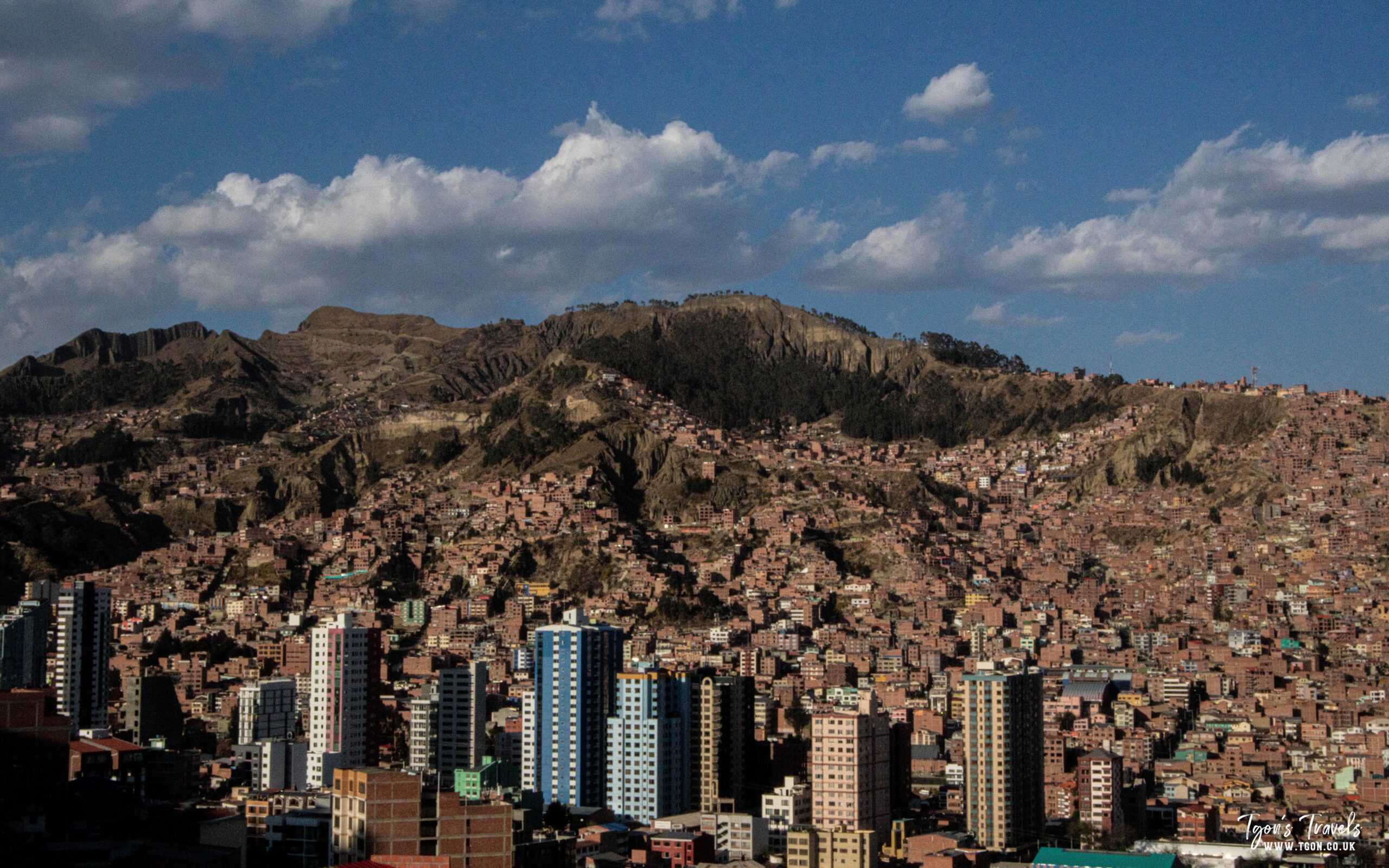
In the morning I sat listening to the birds singing and made some recordings of the sounds before I packed up and continued down through the mountains. I spent a day resting in a hostel in the valley at the bottom of the road before taking the road to Caranavi. Honestly, there isn’t much difference between the standard of the ‘Death Road’ and the rest of the road to Caranavi. Both of them are terrible and gravel covered, passing through mountains. I thought that passing down the ‘Death Road’ would take me out of the Andes and that I would be on more level ground. But I was mistaken. The Andes gently get smaller and smaller for hundreds of kilometers yet. It was a long days ride to Caranavi and when I arrived, the city didn’t look nice at all. It basically looked like a huge truck stop. But I stayed there a day or so and it looked a lot better with a fresh pair of eyes after a nights sleep. The city is sat in the mountains, with wonderful views as you look out of the city. It was while taking a rest day here that I met a French couple who were also cycling into the Amazon. We decided to travel together for the next week as our routes will separate in a town called San Borja. They will head East to Trinidad and I will head north. But we can talk about that next week.

South America Blog Posts

Week 14 – Solo Bikepacking Bolivia. From La Paz to the Bolivian ‘Death Road’

I arrived in La Paz and took a few days to rest. I wanted to extend my visa, as it says 30 days. But the immigration office in La Paz told me that it is actually for 90 days because of my nationality. I am still not really convinced that it will go smoothly when I try to leave. Even if the visa is really 90 days, my passport stamp says 30, so a visa agent at the border could easily try to ask for a bribe. Hopefully this won’t happen though.

La Paz

La Paz isn’t the capital of Bolivia, even though most people think it is. But La Paz definitely feels like the capital. It’s a nice enough city in a beautiful valley surrounded by mountains. Because of this steep landscape, there are cable cars to take you to different areas of the city. There is a mixture of people wearing modern clothing and traditional clothing. As well as a ‘witch market’ to visit. The ‘witch market’ is a tourist area where they sell souvenirs but also have dried dead llamas hanging from the ceilings. It was nice to spend a few days in a big city, but it felt so strange after being out in the middle of nowhere for so long. I spent a few days relaxing in the city before heading off towards the ‘Death Road’.

My hardest day so far

The route to the top of the death road was the hardest day that I have had so far. On the mapping app it looked ok. Only around 58km. I have done more than that already. So I thought it would be an easy enough day. But I made some mistakes which ended up making this the hardest and most dangerous day so far. Firstly, I left too late. I set off at around 11am and started cycling through the city streets. Unfortunately the app that I use was sending me on some strange and unnecessary streets. Turn left and go up a hill, then turn right to come down hill, then left again back up the same hill. Really stupid. Plus I could have taken one of the cable cars to cut a large section of the route. But I carried on and went out to the edge of town.

It was a long steep hill. Basically up one side of a mountain and down the other side of the mountain. It took me 7 hours to cycle and push my bike to the top. Several times I thought I should stop to rest, but then I thought about the altitude and thought it would be too cold. I convinced myself that it was better to get up and over the top. The longer I went, the more I had to keep going. As I got to the top of the mountain the clouds started to blow in. I put on some warm weather gear and kept going, thinking that the clouds would clear as I started to go down the other side. As I got to the top the sun was setting. So I started down the other side of the mountain through thick fog and dark conditions. I couldn’t see far in front of myself as I went down the winding mountain road. I knew it was dangerous but I kept going as slowly as I could, to stay as safe as possible. To make things even worse, my headlight came lose, so if I hit a bump in the road, the headlight would fall forward and point at the floor instead of where I needed to see. I kept going and followed my mapping app to get to the start of the death road.

First view of the ‘Death Road’

When I got to the death road, it was still foggy. But I went down to a community that I had read was a small town at the top of the road. I hoped there would be a small hostel so I could take a shower and sleep in a real bed. But the ‘small town’ was actually around five houses in the mountains. I asked an old woman if there was a hostel, she said there wasn’t. But she said that I could sleep in the viewpoint if I had a tent. I couldn’t even see the viewpoint because of the fog. I could only see around a meter or so in front of my bike. So I used the mapping app to work my way to where the viewpoint was supposed to be and finally found the steps. I climbed up there, set up my tent and then laid on my mattress feeling exhausted. It took me around 30 minutes before I had the energy to cook some food. But then I ate and fell asleep.

The next morning I woke up and opened my tent to the best view that I have ever woken up to. Sleeping in a viewpoint, I should have expected it. But I didn’t even realise I was on the edge of the mountain looking down the valley. It almost made the previous days journey worth it. But from here I was at the end of week 14 and ready to continue down the Bolivian ‘Death Road’.

South America Blog Posts

Week 13 – Solo Bikepacking Bolivia. Flamingos on the long road north.

This week I continued my way along the 550km route north towards La Paz. It was really nice to be back on the bike, out on the open road. Even though the road was sometimes difficult or going through the middle of nowhere. The first few days were difficult but I pushed through and managed to do a decent amount of distance each day. I have been using an app called iOverlander to find camping spots as well as cheap accommodation along the way. Some of the camping spots have been in really beautiful spots, while some others left me wondering why anyone would mark it on the map.

Cheap accommodation & desert roads

The accommodation in some of the towns was very basic. The worst was in a town called Sevaruyo. There was just a small bed in an otherwise empty room with a wooden floor. The shared bathroom was a small toilet room with some brown substance on the floor and a bad smell. The door was broken so it had a huge hole in the bottom and didn’t close. But it was only £2.50 per night and I was only staying one night so it wasn’t so bad. From Sevaruyo the road headed through more long stretches of empty desert. Sometimes it’s nice to cycle through these kinds of places. But when it gets hot and you are starting to get tired, its not so fun. It really made me look forward to getting into the Amazon. Although I’m sure it will be difficult to cycle through the heat there, at least there will be some moisture.

An unusual camping spot

Further north, in a town called Poopo. There was only one hotel in town and it was overpriced at £6.30 per night. I asked around to see if there was another place, but when I found it, nobody answered the door. So I used iOverlander to find a camping spot. The spot that people had suggested was on the road to the cemetery. This was ok except that when I got there there I found a load of animal skins drying in the sun. I didn’t really mind that too much, but then a car drove past slowly and the guys inside were looking at me and my bike. So I decided to look around for a more secluded spot. On the other side of the road there was a raised area hidden by piles of dirt. This was perfect, except that it was just outside the walls of the town cemetery. I don’t believe in ghosts or anything like that, so I decided to sleep there.

An alternate route

The road from Poopo to Oruro went around the edge of a lake. But I could see a small road that cut through the middle of a lake, following some train tracks. I decided to take that road. It wasn’t so interesting for the first half. Just dirt tracks through the desert with a couple of train bridges to push my bike across. But then I got to the lake and everything changed. The clouds were reflected on the surface of the water and there were more flamingos that I have ever seen in one place before. I spent ages there taking in the scenery and flying my drone. For a while I even forgot that I had to cycle another hour or so into town. I really hope that I get more experiences like this as I go through the Amazon. But eventually I had to come back to reality and cycle into town. The roads were terrible, but I was still on a high from the lake. I got to my hostel and had a great nights rest.

South America Blog Posts

Week 12 – Solo Bikepacking Bolivia. Leaving Uyuni & a new route through the Amazon

As I mentioned in my blog post last week, Huong and I will be travelling separately from now on. Huong won’t be cycling and instead she will travel north to Peru and volunteer on a farm for a while. This means that I will be cycling through South America alone. To start my new solo journey, I moved into the Casa de Cyclistas in Uyuni. A Casa de Cyclistas is like a hostel, but is especially for cyclists. There are a lot of these places throughout South America, but there is only one in Bolivia. Luckily it’s in Uyuni, the city that I have been staying in. Its a very basic form of accommodation, just a room with no bed, a shared bathroom and kitchen. But there is no set fee for each night. Instead you pay a voluntary donation for your stay. It was an awesome experience and I am looking forward to visiting more of them as I continue north.

The Cycling Community

The best part of staying there was meeting some other bicycle travellers. When I first moved into the Casa de Cyclistas, there was one other cyclist there. His name is Yuri and he was cycling south after starting in Peru, he is collecting footage for a travel documentary. After I had been there a couple of days, a group of French cyclists arrived. They were also heading south but had started in the United States. It was awesome to meet other cyclists, I have been in South America for 12 weeks already and these were the first cyclists I have met. This is probably my own fault for starting in the south of the continent during winter. I am really looking forward to meeting more of the community as I continue north.

New route and bike adjustments

Yuri actually suggested that I take the route that he had just completed. The route was through the edge of the Amazon, in Peru, Brazil and Bolivia. I’ll leave La Paz, taking the road of death down to the edge of the Amazon. Then up through the Bolivian Amazon to the Brazilian border. I’ll only be in Brazil for a short time before crossing the border into the Peruvian Amazon. The route is over 2000km long and looks like it will be really awesome. The only issue is that my bike has narrow road tyres, not fat off-road tyres. So while I was in the Casa de Cyclistas I took the opportunity to change my back tyre, taking one from Huong’s bike before she sold it. I haven’t managed to get a replacement front tyre yet. Hopefully I can find one before I leave La Paz. But first I need to cycle 550km from Uyuni to La Paz to start this route.

South America Blog Posts

Week 11 – Bikepacking Bolivia. Entering Bolivia and the Salar de Uyuni

This we left Chile and crossed the border into Bolivia. The 48th country I have visited so far. The road from Calama over the border to Uyuni, takes you through some unbelievably beautiful landscapes. The road climbs high into the mountains, passing small villages and huge, snow capped mountains. The border was easy enough to cross. But we weren’t asked for any of the documents that we thought we would need. We just filled in a customs declaration form and got our passports stamped with our new visa. We read that we should have our vaccination certificates, health insurance and an onward ticket to leave Bolivia. We weren’t asked for any of these things. So we got back on the bus and continued through to Uyuni.

Arriving in Uyuni

The driver took a strange route to Uyuni. Instead of staying on the highway, he turned onto a side road that went through the desert. I have no idea why he did this, but the views were great. When we arrived in Uyuni I cut our packing boxes open and rebuilt the bikes in the street. Uyuni is not a nice town. It’s a desert town with nothing to really see or do except go to the Salt flats. We spent a day or so getting everything ready, washing laundry, stocking up of food and water, then we were set.

Camping in the Salar de Uyuni

Uyuni is located high in the mountains of Bolivia. The salar (salt flat) is the largest in the world, over 100,000 square kilometers. During the day time, the sun shines and it is quite warm. But at night time the temperature drops below freezing. We packed our bike and headed into the salar. We cycled out of town and onto the salt flat, cycling into the emptiness until we found a spot that we thought would work well. We set up the tent and cooked some food. It was a windy day, so even the sun shining down on us didn’t do much to increase the temperature. Our main reason to camp in the salar was to see the night sky. Being in a desert and high in the mountains, the night sky is so clear that it is one of the best places in the world to see the stars. This is why there are so many observatories in this region of the world.

A night below freezing

We rested in the tent until around 9 pm. This was half way between the sunset at 6pm and the moonrise at midnight. I got out of the tent and set up my camera. The temperature was below minus 5 and the cold wind blowing across the salar made it even more uncomfortable. I had to get my sleeping bag and wrap it around myself to give a little bit of protection. But each time I took a picture, I just wanted to take another to see if I could capture the sky better than before. It was a horrible situation to be in, but with the beauty of the sky above, it wasn’t too hard to forget the cold. In the morning, all the water bottles were frozen. We made some breakfast, waited until we were warm in the sun and then cycled back into town. Uyuni is a magical place, even if the town isn’t so nice. I would definitely recommend visiting this unique place if you ever get the chance. This is the last part of the trip that Huong will join me for. Starting next week we will be heading on our different routes to experience South America. I have an adventurous route planned to take me from Bolivia to Peru. But I will explain more about that next week.